More than 2,000 individual aerial photographs are now given context and invite you to ‘fly’ across the province of Utrecht.
At the beginning of July, the province of Utrecht put over 2,000 old aerial photographs on the platform hetvolk.org and asked for help from everyone to determine the location of the photographs. In the article the province of Utrecht makes of raw data valuable information we told extensively about this project. Three months later, the province of Utrecht is proud to present the results.
Positively surprised
The province of Utrecht is very positive about the reactions to the photos. “We were pleasantly surprised to see how fast it went and also how accurately the task was carried out by volunteers,” says Viola Tjew a Sin. The aerial photos were provided with the right location (and therefore the coordinates) by enthusiastic volunteers within a few days. This ensured that the province, together with the company Webmapper, could work on a nice presentation of the aerial photos.
More possibilities for use
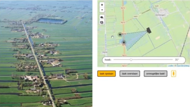
Adding the coordinates to the aerial photos and offering the photos as open data via Dataplatform increases the reusability of the photos. They are easier to find and it offers a lot of possibilities to present the photo collection. The latter was also the aim of the province of Utrecht. Recently, all photos can be seen on www.utrechtinvogelvlucht.nl Select an aerial photo and see on the map from which angle and where the photo was taken. More than 2,000 individual aerial photos are now given context and invite you to ‘fly’ across the province of Utrecht.